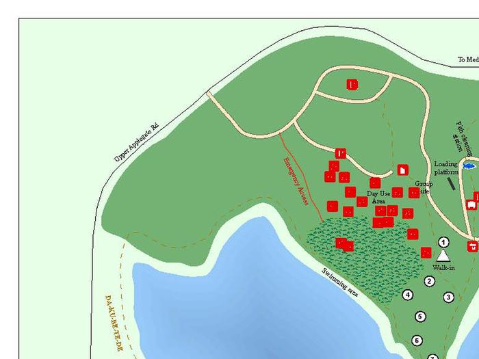
Overview
Located in southwest Oregon in the Rogue River-Siskiyou National Forest, Hart-Tish Park is surrounded by a variety of landscapes, boasting nearby volcanic peaks, rivers and old-growth forests.
Great Facilities and Amenities
Bbq
(8 of 16 campsites have Bbq)
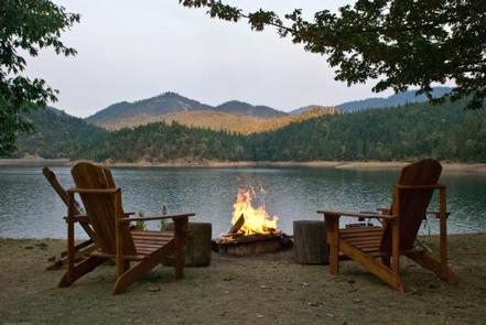
Campfire Allowed
(8 of 16 campsites have Campfire Allowed)
Checkin Time
(8 of 16 campsites have Checkin Time)
Checkout Time
(8 of 16 campsites have Checkout Time)
Driveway Entry
(8 of 16 campsites have Driveway Entry)
Firepit
(All campsites have Firepit)
Max Num Of People
(Up to 15)
Max Num Of Vehicles
(Up to 3)
Pets Allowed
(All campsites have Pets Allowed)
Picnic Table
(9 of 16 campsites have Picnic Table)
Shade
(There are variety of Shade. Such as full and true.)
Site Access
(There are variety of Site Acceses. Such as hike in and drive in.)
Natural Features


The unique character of the landscapes comprising the area has led to the designation of over 340,000 acres of the forest as wilderness, and over 200 miles of streams as National Wild and Scenic Rivers.The forest itself is composed of two distinct geological provinces, the Cascade Range and the Siskiyou Mountains. The Cascade Range is dominated by snow-capped volcanic peaks like the 9,495-foot Mt. McLoughlin, located within the Sky Lakes Wilderness.The Siskiyou area embodies the most complex and treasured plant communities in the Pacific Northwest. World-class wild rivers, biological diversity, remarkable fisheries and complex watersheds all define the Siskiyou.Diverse landscapes provide habitat for a wide range of wildlife, from spotted owls and bull elk to salamanders and sandhill cranes.
Recreation

Hart-Tish Campground sits on the shores of Applegate Lake, a popular recreation lake located north of the Red Buttes Wilderness Area. Visitors enjoy swimming, cycling, boating, canoeing, fishing and hiking the various trails near the lake.Collins Mountain Trail, named for two brothers who mined in this vicinity during the 1850s and 60s, begins at the Hart-Tish Park picnic area. The trail crosses Upper Applegate Road and drops down to Grouse Creek, where it passes an abandoned miners' cabin and several mine adits, as well as an an inactive Bigfoot trap. Leaving Grouse Creek, the trail climbs steeply for one mile to the ridge top, gaining 1,000 foot elevation, and begins a long traverse of the western slope of Collins Mountain.Panoramic views of Applegate Lake and the Siskiyou Crest are seen at several locations along the trail.The inactive Bigfoot trap, found at the beginning of the trail, was built in 1974 by the North American Wildlife Research Team. The trap was inspired by a miner who lived near the Applegate River who claimed to have found 18-inch-long, human-like tracks in his garden. The organization operated the trap, keeping it baited with carcasses for six years, but caught only bears. Currently the Forest Service keeps an eye on the trap, but otherwise does not maintain it.
Permitted Equipment
tent-N/A
rv-Up to 40ft
boat-Up to 40ft
trailer-Up to 40ft
Nearby Attractions
The nearby Rogue River National Recreation Trail, stretching 40 miles between Grave Creek and Big Bend, offers some of southwestern Oregon's most scenic landscapes and rewarding hiking experiences. This hiking-only trail follows the north bank of the Rogue River as it winds its way toward the Pacific Ocean.Visitors enjoy Crater Lake National Park and learning about its unique natural and cultural history. At 1,943 feet deep, Crater Lake is the deepest lake in the United States and one of the ten deepest lakes in the world.